
Alberta is getting a new map for the next provincial election
Boundaries commission collecting feedback on interim report for new riding boundaries

Alberta is getting a new electoral map and the commissioners tasked with the job of redrawing the province’s political boundaries released their interim report in October.
The Alberta Electoral Boundaries Commission is now collecting input about the interim map before the commissioners go back to the drawing board to sketch out their final report, which will be submitted to Speaker Ric McIver by March 28, 2026.
The new map would be used for the next provincial election if it is approved by the Legislature and if a provincial election isn’t called next spring, as some political watchers suspect could happen.
Alberta’s population has grown by around 1 million people since the electoral map was last redrawn in 2017 and one of this commissions biggest challenges is that the population growth has not been equal in every part of the province.
The average population target for the 89 ridings is 54,929, an increase from the 46,803 population average target used in the 2017 electoral boundaries review final report.

The commission has done a fairly good job of keeping most ridings within plus or minus 10 per cent of the average population target, but a few notable exceptions raise questions about how durable the representation in the map would be over the next decade (especially as urban areas are expected to continue growing at a faster rate than most rural areas).
It’s a challenging task made somewhat easier after the United Conservative Party government allowed the total number of ridings to increase from 87 to 89 and removed the rule barring the commission from drawing ridings that crossed the Calgary and Edmonton municipal boundaries.
Boundary commissions in Alberta are composed of five members, including a chairperson (Justice Dallas K. Miller), two commissioners nominated by the governing UCP (Dr. Julian Martin and John Evans) and two nominated by the opposition NDP (Greg Clark and Susan Samson). Alberta has used this bi-partisan system since the mid-1990s and before that the electoral maps were redrawn by a committee of MLAs.
The commission is accepting written responses to the interim report until December 19, 2025 and will begin a new round of public hearings in January 2026. Public hearings are scheduled to be held in-person in Calgary on January 12, 13, and 14, Edmonton on January 19 and 20, and virtually for Northern Alberta on January 15 and South and Central Alberta on January 15 and 16.
Interim report rejects Nathan Neudorf’s proposal to carve Lethbridge into 3-4 big rural-urban ridings
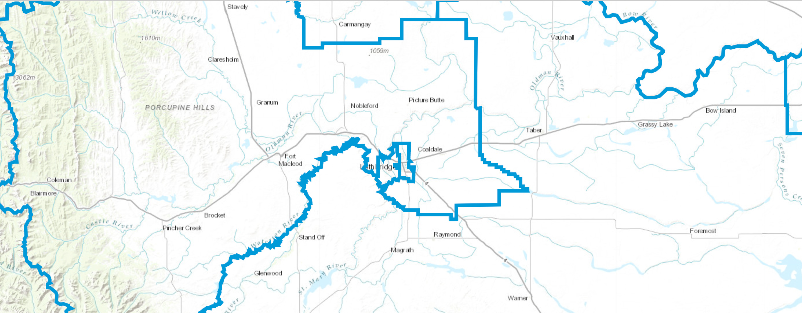
The two urban Lethbridge ridings remain in tact in the interim report despite UCP cabinet minister Nathan Neudorf advocating that the city’s representation be carved up into three or four sprawling urban-rural ridings.
Neudorf, who has represented the Lethbridge-East riding since 2019, submitted a written proposal to the commission calling for the southwest Alberta city to be reconfigured into “three or four complementary ridings that create a cohesive “agri-innovation corridor.” He argued that the dramatic change in the electoral map would give “producers, processors, researches, and urban businesses a unified voice in the Legislature.”

The interim report instead shifts some central neighbourhood polls from NDP MLA Rob Miyashiro’s Lethbridge-West to Lethbridge-East, which is the opposite of what Neudorf had proposed. The two urban ridings have been in existence since the province’s 1971 election.
The interim report proposes the ridings surrounding Lethbridge be redrawn by eliminating Cardston-Siksika, enlarging Livingstone-Macleod, and re-forming a larger version of the Cardston-Taber-Warner riding that existed from 1997 to 2019.
So long Lesser Slave Lake, northern Alberta loses a riding
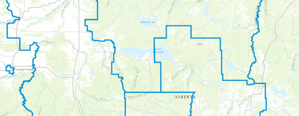
The commission’s decision to remove one riding from northern Alberta has probably generated the most controversy and attention. Independent MLA Scott Sinclair, who saw his Lesser Slave Lake riding completely removed in the interim map, was the loudest critic of the report.
Sinclair was quick to publish an open letter denouncing the interim map as an “attack on democracy” and claim it was part of a partisan attempt to push him out of the Legislature.
“Lesser Slave Lake covered more than 70,000 square kilometers which is two and a half times the size of the Netherlands,” Sinclair wrote. “This new northern riding they’ve drawn is double that size and completely removes the Township of Slave Lake from it. It’s absurd.”
“I’m not even sure how to describe how frustrated I am. Northerners are angry and worried. The math isn’t mathing, as my daughters would say,” Sinclair said. “The UCP chooses division and control over collaboration and solutions. Time and again, they create conflict instead of solving problems.”
The proposed new boundaries draw a provincial riding line straight through the actual Lesser Slave Lake for the first time in the province’s history.
The town Slave Lake and the Sawridge First Nation are moved into a new proposed Slave Lake-Westlock-Athabasca riding and the remaining communities to the west along the lake become part of the large Mackenzie riding that sprawls north towards the North West Territories. The new boundaries also move High Prairie into the neighbouring Peace River-Notley riding.
Concerns about the new northern Alberta boundaries were also expressed in a joint letter signed by northern UCP MLAs Glenn van Dijken, Scott Cyr, Brian Jean, Tany Yao, Nolan Dyck, Ron Weibe, Dan Williams, Martin Long, and Todd Loewen.
“The total elimination of another northern riding, in turn reducing meaningful representation of all northern Albertans, is unacceptable and if allowed to happen will effectively result in an unsustainable map with an ever-growing number of urban constituencies and an ever-growing population of effectively non-represented northern Albertans,” wrote the UCP MLAs.
The UCP MLAs are also uncomfortably looking around at which of their colleagues might challenge them in nomination races ahead of the next election. It’s a situation that always creates unease and tension in a caucus and something that is sometimes unavoidable when the electoral maps are redrawn.
Concerns about the loss of rural ridings were echoed by Town of Valleyview Councillor Samantha Steinke, who was recently re-elected as the UCP’s Vice-President Communications.
In an op-ed published on the Western Standard website, Steinke called for population growth in Edmonton and Calgary to be addressed without decreasing rural representation, the restoration of the two rural ridings proposed for removal in the interim report, and the use of all four exceptions for remote and rural ridings permitted by law in Alberta.
Even with the elimination of one northern riding, the average population of six of the ten of the proposed northern Alberta ridings in the interim report would fall below ten percent of the average target population. This means that northern Alberta could be significantly overrepresented in the Legislature in the next few years if current population growth continues in other parts of the province.
Lesser Slave Lake was one of two ridings included in the 2017 redistribution that were allowed to have a deviation of more than 25 per cent of the average riding population due to remote communities and sparse population. The interim report eliminates the currently existing two special exemptions (the other riding is Central Peace-Notley). The proposed new Mackenzie riding would be the only riding afforded this special exemption if the interim report’s recommendations are included in the final report.
Calgary and Edmonton hybrid ridings on the map
When the UCP government amended the electoral boundaries law to remove the rule that Calgary and Edmonton city limits needed to be respected, there was widespread concern that this would result in a spiral of rural-urban hybrid ridings that could dilute urban representation in the Legislature.
Only a handful of these hybrid ridings attached to the two biggest cities have been included in this interim map:
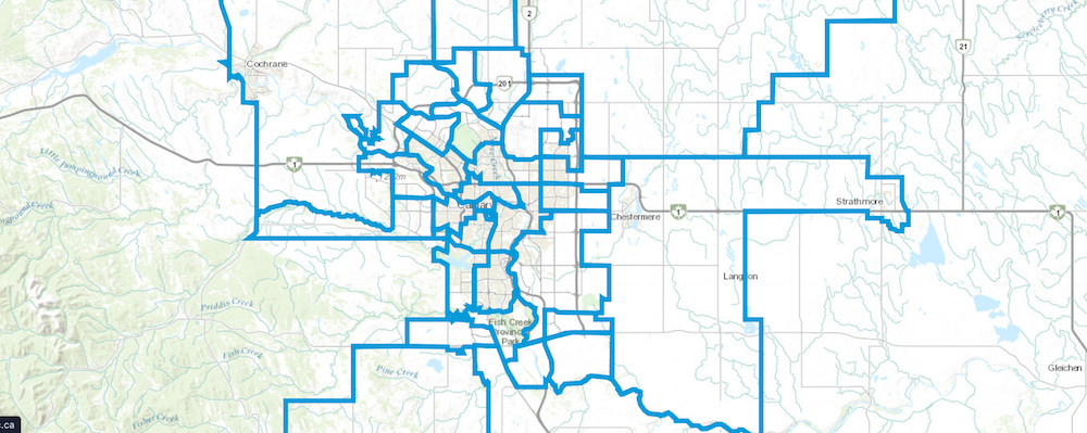
Calgary-Cross includes the the Rocky View County communities of Conrich and Cambridge Park.
Calgary-Okotoks includes parts of south Calgary and the areas south of the city towards the Town of Okotoks. The commission includes two proposed versions of this riding.
Calgary-West-Elbow Valley that includes the current Calgary-West and a funny looking arm that stretches west to the Glencoe Golf and Country Club and its surrounding subdivisions.
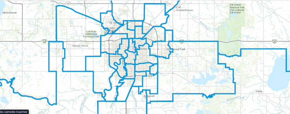
Edmonton-West-Enoch includes suburban neighbourhoods in west Edmonton and the Enoch Cree Nation.
The total number of proposed ridings in Calgary is increased by two and in Edmonton by one. The south east part of Edmonton receives its fourth riding with the proposed Edmonton-South East riding.
Edmonton-Riverview is dissolved, decreasing the number of ridings in central Edmonton from six to five, as a result of lower population growth in the city’s central neighbourhoods compared to the suburban areas. The riding that was created in the 1997 election is absorbed into the larger proposed Edmonton-Glenora-Riverview and Edmonton-Strathcona ridings.
Other changes of interest
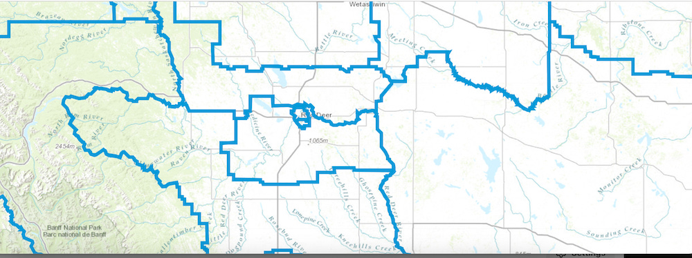
Central Alberta’s electoral map is completely redrawn, with the existing Lacombe-Ponoka, Olds-Didsbury-Three Hills, and Rimbey-Rocky Mountain House-Sundre ridings redistributed into new ridings. Central Alberta’s ridings are decreased from six to five to reflect a slower than average population growth in the region.
The growing commuter communities north and west of Calgary have been reorganized into three proposed new ridings: Airdrie-East, Airdrie-West and Cochrane-Springbank.
The sprawling Drumheller-Stettler riding is left largely untouched, with the exception of the addition of the town of Hardisty, even though its average population is 23% above the provincial average under the proposed new boundaries.
The City of Beaumont is split into two, with the city’s 50th Street acting as the dividing line between Leduc-Beaumont and Strathcona-Sherwood Park.
Spruce Grove and Stony Plain are divided, with a new Spruce Grove riding extended north into Parkland County, and Stony Plain being included as part of the Stony Plain-Drayton Valley-Devon riding that sprawls southwest into Brazeau County.
The towns of Barrhead and Westlock would be moved into different ridings for the first time since the 1989 election. Barrhead would be moved into the Lac Ste. Anne-Parkland riding and Westlock into the Slave Lake-Westlock-Athabasca riding.
The mountain parks and towns included in the proposed Banff-Jasper riding that climbs along the Rocky Mountains include Canmore, Banff, Jasper and areas west of Rocky Mountain House. This brings together communities of interest that were separated into different ridings and, politically, creates what should be a fairly safe NDP voting riding.
Interim boundaries transposition
has prepared a transposition from the results of the 2023 Alberta election into the proposed new boundaries that shows the UCP winning 48 ridings and NDP winning in 41. The NDP would win the new Calgary-Confluence, Calgary-Nose Creek, and Edmonton-West-Enoch ridings under the 2023 results.UCP MLA Mickey Amery in Calgary-Cross and NDP MLA Diana Batten in Calgary-Acadia would be put in “dicey situations” under the new boundaries, according to Hutton’s numbers.

Thank you for reading!
Thank you for reading and subscribing to Daveberta. It continues to be a real pleasure to be able to write about Alberta politics and history and share it with so many of you through this platform.
If you like what you read here today, please feel free to share it with your friends and colleagues. And if you have any feedback or questions about today’s post, feel free to leave a comment below or email me at david.cournoyer@gmail.com.
Thanks again,
Dave
